
Here I sit, waiting patiently to go out and play. I am in the recovery window where no further physiological tweeks can be had. All that can happen between now and then is bad: illness, injury, overuse, under sleep... all the dirty words in a runner's vernacular. The game now is just enough running and more than enough rest; mental and physical, to allow that perfect day of running to occur within me.
The Chattooga 50k is NEXT weekend, which means another year has passed (actually a year plus 3 weeks with a new race date for 2011) and another chance to measure myself against The Standard. Here is the comprehensive low down on this challenging course which is run along the South Carolina side of the Chattooga River watershed. NOTE: 2012 edition is back to June 3rd.
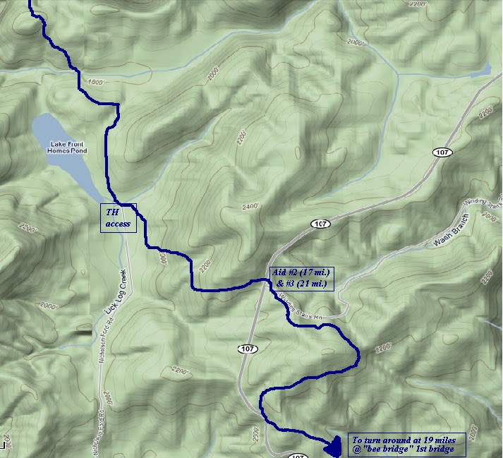
Section I. Winding Stairs- (7 miles round trip)
Leaving Cherry Hill Campground the runners begin on a nice smooth, flat dirt road. Don't get use to it, this is a trap for those who haven't run these trails before and you are best served here to settle into your easiest pace, get the blood moving gently and rustle the mind's cobwebs from the 7 am start... and to let someone else clear the spider webs from the course.
Upon leaving the dirt road in the Cherry Hill Campground, the course hits the single track to the left and runners find themselves on a gradual downhill on the Winding Stairs trail. About a mile in, the course begins falling with switch backs over water run-off. Here is the first chance to get your feet wet! The sounds of the soothing waterfalls below now become available. Another trap here... the trail is SO effortless you might be tempted to go ahead and lay down some fast mileage... for the bank... Personally, I use it to my advantage and cover the ground with as little energy as possible, you'll want that gumption later on as the steps mount on your shoulders and you enter the crux of the race... later in the afternoon, in the heat and in those multiplying hills.
 3.5 miles into the run the course reaches a trail head and parking area, here is your turn around and the last easy steps for a long while. Though the climb out seems casual it is still climbing and you'll do well to stay aerobic, keep the running efficient, and move gently up with the terrain. Chattooga is all about conservation, get a big head and you're dead. After 7 miles the course breaks off to the left and away from the Winding Stairs trail, onto a little climbing connector trail which leads to a sunlit canopy above the first Aid Station at the junction of Highway 107.
You will want to make the most of this stop because you are about to enter a meat grinder, a beautifully rugged, 10 mile stretch of unaided running with every kind of hill known to man.
Section II. Big Bend to the Foothills Trail (10 miles between Aid)
The downhill running resumes, and at times it is very steep and technical through here. But, most of the Big Bend trail is gentle, smooth and careening with sweeping turns.
You also find the first small foot bridges and you will want to be sure of your footing on each and every one of these bridges, they can be and likely will be very slick, despite their appearance and any apparent conditions. Take your time to be cautious on these bridges or they could cost you your day!
About 4 miles into Section II the Big Bend trail intersects with the Foothills Trail. Now the course runs along with the flow of the mystical Chattooga River. Here is your chance to get some help from the magical waters to your right. I suggest a quick baptism to maintain or lower core temperature, even early on. The time you spend might pay dividends as your time accumulates and the ambient temperature builds.
(Just watch out for your shorts).
There is some fast miles in here, flat, fast and sandy. You will see your first campers, just waking up from their wilderness comas, also fishermen who are angling for a catch will be shocked (or offended) to see these strange sweaty folks running through "their" watershed with safety pinned numbers affixed. But you will just nod and smile and make your way along the summer morning. There are a few trail options on this flat portion or land and as long as you are running downriver you are okay. Don't sweat it, each trail here will bring you to the center of the web, just stay in a downriver direction. Run like water and these small trails will again collect into one strong trail.
To this point the hills have come in longish stretches. Now, you will begin the jumbly roller coaster as the trail moves away and up from the river. You will climb up away and fall back downward in little chunks and your legs will begin to be tenderized by these short, steep climbs. The heat will begin to stick to you and every cool breeze should be cherished as if the last you will ever experience. The woods get thick and muggy later in the day, best to cool off whenever/ however you can and manage the heat!
As you move through these hills and up above the Chattooga River you will again enter the quiet of the forest away from any water for a couple of miles before entering another camping hot spot, almost a village there are often so many out here for the weekend. Again a few choices for how to get through here, just move through the camp spots (actual trail moves around to the left) and end up at a short (very steep) section of crumbling stairs.
There will be VERY SLICK bridges here too, so take even more caution crossing these as you will not be as fresh now and runners have been injured here. You will have covered about 13 miles and while still feeling great there could be a crack or two in your coordination with the undulating terrain, technical trail and mid morning heat taking effect on your concentration. Also be aware that many day hikers will be on the trail now too, beginning their day from a small parking area.
Once you reach the parking area you have a prolonged climb of a 1.5miles or so to reach the next aid station. You will slowly begin to hear the traffic on Hwy 107, it takes longer than you think to get there, so drink up, eat up and move up the hill. A break is almost here!
To the Bee Bridge Turnaround (4 miles- round trip)
Reaching Hwy 107 again you are at Aid Station #3. Take in your fluids now- eat- get your salt- and continue to stay patient. Then onto a short 4 mile out and back stretch which is crucial to setting up your successful finish, or destroying your state of being.
You have covered 17 miles when you arrive at the second Aid Station and you will see people!!! and they will be encouraging, and you will believe what they tell you, but remember, you have the hardest sections left to cover and they begin at the Bee Bridge. You need to take the smiles and convert them into patience. Recenter to your plan, you have completed nothing yet.
You now get two miles of downhill careening turns in a drier (and more exposed-sunlight) section of the trail, this section is usually more sun hot, but less muggy and you will be exposed to some direct sunlight in areas. You might come upon mountain bikes as this portion of the FHT leads to Oconee State Park (eventually) but we won't go that far.
Just run downhill, smoothly, until you reach the 1st bridge, (The Bee Bridge- if you are allergic to bee stings be prepared). Give the bridge a tap, or play it like a drum if you want... then turn around and begin your 2 mile trudge returning to the Aid Station (now #3) on Hwy 107.
You will be a changed person now, this 2 mile segmented climb will wear on you, it is hard, maybe the most difficult section of the course on its own merit.
Upon arriving at this aid station #3 back on Hwy 107 (and your FINAL aid station essentially- there is an Aid #4 less than a mile from the finish) take in as much fluid and positive energy as you can because you are now entering the Chattooga 50k proper- the essence of this race, the reason to run Chattooga... you are entering The "PTSD 10".
Section IV- PTSD 10 (10 miles)
This is the final section to the finish (sans the Winding Stairs portion) at Cherry Hill Campground. But first you need to re-run that 10 mile stretch along the FHT to Big Bend, and this time it will look and feel much different.
Those 'little' hills you hadn't noticed the first time out will have multiplied and expanded in magnitude. Those roots you didn't see on your way out will have grown tentacles and can grab you when you aren't looking. The water you are carrying will turn to lead... even the feet and legs and hips you took such good care of will turn tender and stiff and ask for you to walk for just a minute. The firm trail is crumbled, there a down trees with no easy way through now and your only tool to combat this is your mind.
The demons have waited for their moment and they will find you and finish you off out in the PTSD 10. This section is best run the way you have run the whole time, patiently. If you can make mental notes of landmarks on the way out- they will be useful to you during the PTSD 10...
The Chattooga 50k is NEXT weekend, which means another year has passed (actually a year plus 3 weeks with a new race date for 2011) and another chance to measure myself against The Standard. Here is the comprehensive low down on this challenging course which is run along the South Carolina side of the Chattooga River watershed. NOTE: 2012 edition is back to June 3rd.
 |
| Section One, Winding Stairs |
Leaving Cherry Hill Campground the runners begin on a nice smooth, flat dirt road. Don't get use to it, this is a trap for those who haven't run these trails before and you are best served here to settle into your easiest pace, get the blood moving gently and rustle the mind's cobwebs from the 7 am start... and to let someone else clear the spider webs from the course.
Upon leaving the dirt road in the Cherry Hill Campground, the course hits the single track to the left and runners find themselves on a gradual downhill on the Winding Stairs trail. About a mile in, the course begins falling with switch backs over water run-off. Here is the first chance to get your feet wet! The sounds of the soothing waterfalls below now become available. Another trap here... the trail is SO effortless you might be tempted to go ahead and lay down some fast mileage... for the bank... Personally, I use it to my advantage and cover the ground with as little energy as possible, you'll want that gumption later on as the steps mount on your shoulders and you enter the crux of the race... later in the afternoon, in the heat and in those multiplying hills.
3.5 miles into the run the course reaches a trail head and parking area, here is your turn around and the last easy steps for a long while. Though the climb out seems casual it is still climbing and you'll do well to stay aerobic, keep the running efficient, and move gently up with the terrain. Chattooga is all about conservation, get a big head and you're dead. After 7 miles the course breaks off to the left and away from the Winding Stairs trail, onto a little climbing connector trail which leads to a sunlit canopy above the first Aid Station at the junction of Highway 107.You will want to make the most of this stop because you are about to enter a meat grinder, a beautifully rugged, 10 mile stretch of unaided running with every kind of hill known to man.
Section II. Big Bend to the Foothills Trail (10 miles between Aid)
 |
| Sec. II: Big Bend to FHT |
You also find the first small foot bridges and you will want to be sure of your footing on each and every one of these bridges, they can be and likely will be very slick, despite their appearance and any apparent conditions. Take your time to be cautious on these bridges or they could cost you your day!
About 4 miles into Section II the Big Bend trail intersects with the Foothills Trail. Now the course runs along with the flow of the mystical Chattooga River. Here is your chance to get some help from the magical waters to your right. I suggest a quick baptism to maintain or lower core temperature, even early on. The time you spend might pay dividends as your time accumulates and the ambient temperature builds.
(Just watch out for your shorts).
There is some fast miles in here, flat, fast and sandy. You will see your first campers, just waking up from their wilderness comas, also fishermen who are angling for a catch will be shocked (or offended) to see these strange sweaty folks running through "their" watershed with safety pinned numbers affixed. But you will just nod and smile and make your way along the summer morning. There are a few trail options on this flat portion or land and as long as you are running downriver you are okay. Don't sweat it, each trail here will bring you to the center of the web, just stay in a downriver direction. Run like water and these small trails will again collect into one strong trail.
 |
| Continue Sec.II on FHT to Hwy 107 |
As you move through these hills and up above the Chattooga River you will again enter the quiet of the forest away from any water for a couple of miles before entering another camping hot spot, almost a village there are often so many out here for the weekend. Again a few choices for how to get through here, just move through the camp spots (actual trail moves around to the left) and end up at a short (very steep) section of crumbling stairs.
There will be VERY SLICK bridges here too, so take even more caution crossing these as you will not be as fresh now and runners have been injured here. You will have covered about 13 miles and while still feeling great there could be a crack or two in your coordination with the undulating terrain, technical trail and mid morning heat taking effect on your concentration. Also be aware that many day hikers will be on the trail now too, beginning their day from a small parking area.
Once you reach the parking area you have a prolonged climb of a 1.5miles or so to reach the next aid station. You will slowly begin to hear the traffic on Hwy 107, it takes longer than you think to get there, so drink up, eat up and move up the hill. A break is almost here!
To the Bee Bridge Turnaround (4 miles- round trip)
Reaching Hwy 107 again you are at Aid Station #3. Take in your fluids now- eat- get your salt- and continue to stay patient. Then onto a short 4 mile out and back stretch which is crucial to setting up your successful finish, or destroying your state of being.
You have covered 17 miles when you arrive at the second Aid Station and you will see people!!! and they will be encouraging, and you will believe what they tell you, but remember, you have the hardest sections left to cover and they begin at the Bee Bridge. You need to take the smiles and convert them into patience. Recenter to your plan, you have completed nothing yet.
 |
| Sec. III- to the Bee Bridge |
Just run downhill, smoothly, until you reach the 1st bridge, (The Bee Bridge- if you are allergic to bee stings be prepared). Give the bridge a tap, or play it like a drum if you want... then turn around and begin your 2 mile trudge returning to the Aid Station (now #3) on Hwy 107.
You will be a changed person now, this 2 mile segmented climb will wear on you, it is hard, maybe the most difficult section of the course on its own merit.
Upon arriving at this aid station #3 back on Hwy 107 (and your FINAL aid station essentially- there is an Aid #4 less than a mile from the finish) take in as much fluid and positive energy as you can because you are now entering the Chattooga 50k proper- the essence of this race, the reason to run Chattooga... you are entering The "PTSD 10".
 |
| An overview of the course |
This is the final section to the finish (sans the Winding Stairs portion) at Cherry Hill Campground. But first you need to re-run that 10 mile stretch along the FHT to Big Bend, and this time it will look and feel much different.
Those 'little' hills you hadn't noticed the first time out will have multiplied and expanded in magnitude. Those roots you didn't see on your way out will have grown tentacles and can grab you when you aren't looking. The water you are carrying will turn to lead... even the feet and legs and hips you took such good care of will turn tender and stiff and ask for you to walk for just a minute. The firm trail is crumbled, there a down trees with no easy way through now and your only tool to combat this is your mind.
The demons have waited for their moment and they will find you and finish you off out in the PTSD 10. This section is best run the way you have run the whole time, patiently. If you can make mental notes of landmarks on the way out- they will be useful to you during the PTSD 10...
- "Parking lot... 8 miles to go..."
- "Slick bridge... 7 miles to go..."
- "Back to the river... how far to go??? Where am I? ...and all up hill from here... fantastic!"
- "Today's date is hot and I drink roots from oxygen hills..." your world has become a bad Mad-Lib
BUT- As you again run along the flat and sandy portion upriver on the Chattooga River you are honing in on a successful finish, though, you have a couple of things to take care of first.
- "Look kids, its Big Bend trail" Big Bend is usually marked well enough, but when you leave it on the way out, treat this like a solo trail run and be sure YOU KNOW WHERE THE JUNCTION IS. The runner with you on the way out might not be with you now, or you might be talking and get distracted or whatever... BUT- make notes at important junctions on this course on the way out, turn back and see what it actually looks like on the return. Bonus miles now are not fun and every junction is an important one... So- stop, look around you BACK at where you came from on the way out, so you will SEE IT when you need to! Catch Big Bend!!!
- Big Bend is on the right.
- It is not across the river.
- It is not straight ahead.
- It IS on your right, yes, up THAT hill. Go Up!

- Once on Big Bend trail settle back down... because that once screaming, downhill, technical, log strewn hill from the way out (at 9 miles in... when you felt great) is still waiting for you. Now those log hurdles are higher up across the trail, the dirt has turned to ball bearings and the heat is on full force. That hills stares down like you were an ant under the magnifying glass- don't take it personally... just take it and get out of there.
- The good news... well there isn't much good news at this point, except that if you keep going you have some nice smooth trail up top with minimal elevation changes, and only 2-3 miles to go from the top! You cover this one step at a time, very literally. There isn't any other way out!
Okay, 2ish miles to go!
Now it gets fun, and you only had to wait 29+ miles for it... too bad you are too exhausted to enjoy:) It is now afternoon, you are running (maybe, ideally) in the heat of June in the south. You are out of water and food and feeling like a bear attack would be a welcomed option at this point. Heck, even an approaching banjo tune could be a relief.
But don't despair, your positive thoughts CAN carry you in from this point forward. The major work is gone and you can almost coast in from here... beer is near as well as the cool creek at the campground to sit in!
 |
| Thanks to Georgia Snail for this graphic |
You will re-cover the sweeping turns of Big Bend and come upon those initial foot bridges again, be really careful crossing. After passing a small waterfall (you can hear it somewhere around you..???) you have just a short climb to Aid Station #4 (#1) at Hwy 107... this place is likely deserted now, but turn right, back up that cresting connector trail.
You are back at Cherry Hill Campground and your only task now is to run that final few minutes of trail, turn left at the junction after the downhill and get back onto that (sweet gravel) road to the finish line wherever it is this year!
Congratulations you have earned it on this challenging course! You have learned something new about what it means to cover "50k".
Now, soak in the stream, eat some great burgers, get a cold one or two or three... (hard to keep count now anyway right...) and try not to wretch too badly in public... it makes you look weak and unattractive ;)
Happy Running!
Thanks for this inspiring low-down on Chattooga. It has really re-kindled my excitement for the run.
ReplyDeleteSo looking forward to meeting the fam, too:)
Have a wonderful Father's Day Sunday.
Psyche
My 1st ultra last year and you are wise to note numerous times about the bridges. I knew they were slick but still took a hard fall on the 1st one and even walking on the 2nd one almost fell. Best of luck this year - makes me want to run it again...maybe 2012.
ReplyDeleteSean I noted that you won this race. Was it 4:37? You're in a prime place in your endurance sport life. I enjoy the perspective vs. my own timeline in the sport. My best was 4:57 for 50K. Congrats on having the motivation to succeed.
ReplyDelete